
Seat Leon >> Navigation
Introduction
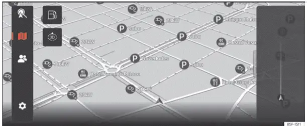
Fig. 175 Schematic representation: Navigation
view.
A global satellite navigation system continuously determines the exact geographic position of your Seat Leon, while vehicle-mounted sensors analyze the driven routes and wheel rotation data.
All measured sensor values and reported real-time traffic events are compared against onboard navigation maps to calculate and guide you along the optimal route to your destination.
Turn-by-turn voice announcements and clear graphic illustrations on the screen will guide you reliably to your target destination.
Route planning and navigation functions are managed directly via the central touchscreen.
Depending on local country regulations, certain infotainment system functions are restricted or locked on the screen when driving above a specified vehicle speed. This is not a system malfunction, but a safety feature implemented to comply with local traffic legislation.
Navigation announcements
Navigation announcements provide spoken audio instructions for driving maneuvers relating to your active route.
The type, phrasing, and frequency of navigation announcements depend on the current driving situation—such as initiating route guidance, driving on a motorway, navigating a roundabout—as well as your custom user settings.
If your exact destination cannot be reached directly because it is located in a non-digitized area or private zone, advisory details regarding the closest address and remaining straight-line distance to the destination will be shown on the screen.
During active dynamic route guidance, you will receive automated updates concerning reported traffic congestion along your route. An additional navigation announcement will sound if the system recalculates your route to bypass a traffic jam.
While a navigation announcement is actively playing, you can adjust its playback volume using the volume controls. Subsequent navigation announcements will then be broadcast at this newly adjusted volume level.
Limitations during navigation
If the infotainment system temporarily loses GPS satellite reception—for example, when driving through a long road tunnel or an underground parking garage—dead-reckoning navigation continues seamlessly using data from the vehicle's internal sensors.
In geographic areas that are not digitized or are only partially mapped in the infotainment system's memory, the system will still attempt to provide rough route guidance based on available road networks.
In cases of missing or incomplete map data, determining the exact vehicle position can be challenging, which may cause navigation precision to be lower than usual.
Road layouts and street networks are subject to constant real-world changes (such as newly constructed roads, active roadworks, temporary road closures, updated street names, and modified building numbers). Operating with obsolete navigation database versions can lead to routing errors or temporary inaccuracies during travel.
Managing the navigation map
For an optimal viewing experience, you can interact with and manipulate the navigation map using intuitive multi-touch finger gestures.
Moving the map
Tip: use your index finger.
- Drag the map across the screen in any direction with your finger to pan.
Zooming into or out of the view
Tip: use your index finger.
- Tap twice quickly on the map and keep your finger pressed against the glass screen after the second tap.
- To zoom out and get a broader map view, slide your finger upward. To zoom in for a closer view, slide your finger downward.
Change the 2D / 3D view
Tip: use your index and middle fingers.
- Press down on the map with both fingers simultaneously and hold them steady on the screen.
- To switch to a flat 2D top-down view, scroll your fingers downward; to switch to a perspective 3D view, scroll your fingers upward.
Rotate the map
Tip: use your thumb and index finger.
- Press down on the map with both fingers at the same time and keep them resting on the screen.
- To rotate the map orientation, pivot your fingers clockwise or counter-clockwise in a circular motion.
Saved data
Your Seat Leon infotainment system automatically stores specific navigation data, such as frequently visited routes and recent position history, to make future destination entry faster and optimize ongoing route guidance.
Delete saved data
- Press Settings > Basic function settings > Delete and then confirm by selecting Accept.
WARNING Always select configuration settings, enter destination addresses, and make navigation adjustments only when your vehicle is parked safely at a standstill.
Note
- If you drive past a recommended turn or encounter an unexpected detour, the navigation system will instantly recalculate an alternative route.
- The overall quality of routing recommendations provided by the infotainment system depends directly on the up-to-date status of available map data and real-time traffic congestion reports.
- Navigation audio announcements will not be emitted if the system volume or navigation guidance audio is set to mute.
 Media Mode
Introduction
Fig. 174 Schematic representation: Media view
In Media mode, you can play your favorite multimedia files directly from connected data storage media through your Seat Leon infotainment ...
 Telephone interface
Introduction
Fig. 176 Schematic representation: Phone view.
You can use the built-in telephone interface to connect your mobile phone to the infotainment system and operate hands-free phone functi ...
See also:
Removing and installing subwoofer
R211
removing
Switch off ignition and all electrical equipment.
Vehicles without access and start authorisation system
Remove ignition key, if fitted.
Vehicles with access and start authorisa ...
